
Continent
Geography features
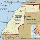
Map with country labeled
Education
Important resources
4 points of interest
Official language
3 interesting facts
Neighboring countries
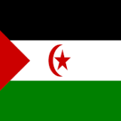
Country’s flag
GDP
Timeline of 5 historical events
Food
Currency
population
Climate
$2,500 per capita
1884 Spain colonized the region now known as Western Sahara. 1934 Western Sahara becomes a Spanish province, and becomes known as Spanish Sahara. 1960’s Nationalism emerged in the 1960s, as nomadic Saharans, or Sahrawis, settled in the region. 1965 The UN urges the decolonization of Western Sahara. 1975 Beginning of guerrilla warfare between the POLISARIO and the Moroccan Army
Mauritanian Ouguiya
619,551
Morocco, Algeria, Mauritania
You can see the L’ile Herne, the Assona and Laayoune mosque, and the st. francis of assisi cathedral
Standard Arabic
hot, dry desert; rain is rare; cold offshore air currents produce fog and heavy dew
Africa
Peanut, camel, goat, few fruits and vegetables
The Sahara desert, small mountains in the south and northeast.
rich fishing waters, and potential oil deposits.
1. The lowest point is Sebjet Tah at 55 m and the highest point is an unnamed located at 463 m. 2. The economy is small market-based. Main industries are phosphate mining and handicrafts. They import fuel for fishing fleet and foodstuffs. 3. Western Sahara is one of the most sparsely populated territories due to the fact that the area mainly consists of desert flatlands.
Morocco has stretched its educational system throughout Western Sahara. The educational system follows the Moroccan model where, in public schools, the education is free from the primary to the university schools

